About iNautical
iNautical provides an electronic means to purchase and store incredibly high resolution (10 megapixel) maps of many fishing and boating destinations throughout the US. These are electronic versions of the same maps...
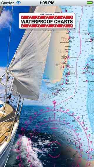
iNautical provides an electronic means to purchase and store incredibly high resolution (10 megapixel) maps of many fishing and boating destinations throughout the US. These are electronic versions of the same maps produced by WaterproofCharts.com and used by the United States Navy and Coast Guard. Many of our charts combine multiple NOAA charts into one document along with fishing locations, boat ramps, restaurants, fueling stations, waypoints, and GPS coordinates...all the information you need to have a great day on the water. To get you started, one complete map, "Florida to Puerto Rice & Mona Passage", is included for free with the reader program. If you don't find the chart you're looking for, check back often. Our dedicated staff is digitizing more of our full library of charts every week!
Requires iOS 4.3 or later. Compatible with iPhone, iPad, and iPod touch.
Previous Versions
Here you can find the changelog of iNautical since it was posted on our website on 2016-09-29 11:45:43.
The latest version is 1.3 and it was updated on 2024-04-22 20:10:41. See below the changes in each version.
iNautical version 1.3
Updated At: 2011-06-17
Disclaimer
Official App Store Link
We do not host iNautical on our servers. We did not scan it for viruses, adware, spyware or other type of malware. This app is hosted by Apple and passed their terms and conditions to be listed there. We recommend caution when installing it.
The App Store link for iNautical is provided to you by apps112.com without any warranties, representations or guarantees of any kind, so access it at your own risk.
If you have questions regarding this particular app contact the publisher directly. For questions about the functionalities of apps112.com contact us.